About Venezuela
Venezuela, sitting just above the equator in South America, has a diverse range of climates. While the whole country is within the tropical climate zone, great topographical variation dictates great regional variation in climate, largely based on elevation. Generally, it is very hot but while you will find lush rainforest and sun-drenched beach fronts, Venezuela also has snow-capped mountains. The country has a wet season from May till November and a dry season from December till April, but the length and intensity of the wet season vary with location. Southerly regions generally receive much higher levels of rain than the more northerly regions.
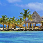
Venezuelaâs north border is with the Caribbean Sea and it has a number of islands just off the coast. The Carribean Islands, including Isla Margarita and the Los Roques archipelago, and coastal regions of Venezuela enjoy an arid tropical climate. High temperatures and high humidity exist year round. Rainfall provides some seasonal variation, but not a great deal. The rainy season does not see a dramatic increase in rain. Storms increase in frequency but are very short. The temperature stays around 30°C year round, with sticky nighttime lows in the mid-20s. The area is just south of the hurricane belt and does not receive direct hits, though can experience severe storms when one of these tropical cyclones passes nearby. Northeast trade winds help to temper the heat a little, but nothing can really make 30°C heat and high humidity easy to acclimatise to. The wind direction means that northeast facing areas and regions receive more rain than southwest areas. The region receives much less rain than might be expected for a tropical region; nearby Aruba and St Lucia are much wetter. This is due to the long mountainous terrain stretching along Venezuelaâs coastline which attracts and blocks humid air, depriving northerly regions of precipitation.
Further inland the elevation increases and a tropical savannah climate prevails. This covers the northern portion of the country, save for its coastal regions and mountains above 2000 metres. Temperatures are cooler than on the coast and very little from season to season; Caracas, the capital, sees an average high of 27°C in its hottest month and an average low of 25°C in its coolest. Valleys, such as the one in which Caracas sits, are often foggy in winter months and can sometimes see nighttime lows below 10°C, though this is considered rather peculiar. The wet season in this region is more intense with heavy storms that can cause floods, and the dry season is drier. Again, northeast areas receive higher rainfall due to the direction of the trade winds. While the region is further inland and might expect larger temperature variations from season to season, Venezuelaâs near equatorial position allows for very little seasonal variation in temperature.
Tropical rainforest hugs the south Orinoco River valley and delta, the southwest regions of Maracaibo Lake and all of southern Venezuela in the Amazon region, including the Guiana Highlands. The rainforest is hot and humid with daily rain storms and sun when it isnât raining. The wet season sees almost twice the amount of rain that the dry season receives. The dry season can see up to 2500 mm of rain, and the wet season can see up to 4500 mm. The temperature is usually in the high 20s. A steady climate with high temperatures and plenty of rainfall in combination with the fertile soil of South America created the immense Amazon rainforest of which Venezuela is the proud owner of a small portion. The country once heavily exploited the rainforest but banned commercial logging and mining in 1989 and half of the country is now under legal protection. However, corruption, guerrilla groups and man-induced climate change continue to eat away at the forest despite the governmentâs earnest and realistic view on the importance of conservation.
The Guiana Highlands in the southeast of the country is part of the Guiana Shield, a low mountain and plateau region that also covers east Colombia, north Brazil, Guyana, Suriname and French Guiana. The area has elevations from 1000 - 3000 metres and receives a tropical highland climate typified by high humidity and high temperatures. This is the home of Angel Falls, the worldâs highest waterfall. While it is best to visit Venezuela in the dry season, Angel Falls is actually more impressive in the wet season due to the greater volume of water that crashes down after heavier rainfall. Ciudad Guyana sees day time highs consistently into low to mid-30s and nighttime lows in the low 20s. The town sees much lower rainfall than regions further south. Due to the mountainous, difficult to travel across, the terrain of the area, settlements are usually to be found near rivers, and so are lower down, receiving high temperatures. Ciudad Guyana sits on the northern section of Orinoco River. The town receives much less rain and lower humidity than Puerto Ayacucho which is further south on the western stretch of Orinoco River. This follows the trend of wetter weather towards the south seen across Venezuela.
While lower regions of the Andes are also covered in dense rainforest, its highest parts, at and above 3000 metres, receive an alpine climate: rainy with an average temperature of 18°C. Climb higher and you will find permanent snow, starting around 4500 metres. Venezuelaâs Andes is the northern section of the mountain range, drier than the central section and warmer than the southern section. They are home to five cirque glaciers, formed in high-up depressions. The melting of the glaciers in the dry season has long been a supply of fresh water to lower, surrounding regions, but global warming is causing more extensive melting in summer months, depleting these frozen reservoirs.