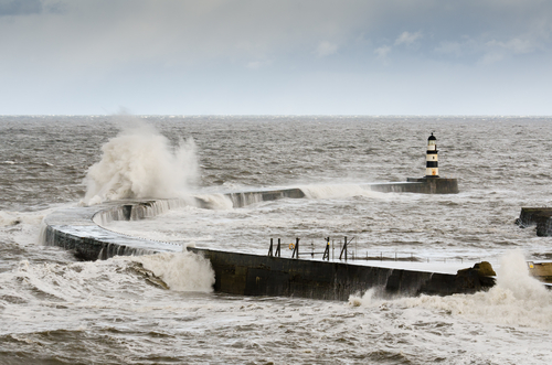
As forecast the remnants of ex-hurricane Bertha crossed the UK over the weekend bringing heavy and strong, gusty winds.
The low pressure system moved in from the southwest overnight on Saturday into Sunday bringing up to 40 mm of rain to parts of south Wales and winds gusting in excess of 50 mph around the coasts of southwest England.
The heavy rain continued to move north and east during the course of today (Sunday 10 August), with strong and gusty winds being the main feature for most areas with gusts of 40 – 50 mph expected quite widely.
Chief Meteorologist, Paul Gundersen, said: “We’re seeing the impacts of this unseasonable weather across the UK, with heavy rain and thunderstorms bringing the risk of flooding in some places.
“The westerly wind is expected to gust around 40-50 mph quite widely, perhaps in excess of 60 mph – this most likely across the Pennines where isolated gusts as high as 70 mph are possible. At this time of year, these wind strengths can lead to some disruption and tree damage and people should stay up to date with the latest Met Office warnings.”
Neil Davies, Environment Agency Flood Risk Manager, said: “This low pressure system is bringing widespread rain and some intense downpours that may lead to localised surface water flooding in central and northern parts of England. The combination of strong, gusty westerly winds and high spring tides bring a risk of spray and wave overtopping leading to a risk of localised coastal flooding along parts of the south-west, north-west and north-east coasts of England.
“We have issued a number of flood alerts and warnings across the country, with the possibility of further coastal and river alerts being added later today. We advise people to keep up to date on the latest situation by checking flood risk on the Environment Agency website and listening to local radio. Respect the weather and don’t put you or your loved ones at risk by driving through flood waters or getting too close to large waves. Stay safe, keep clear of promenades and don’t be tempted to put yourself at risk
“The Environment Agency is continuing to monitor the situation closely along with the Met Office, and is working closely with local authorities and emergency services to ensure we’re ready for whatever these unsettled conditions may bring. We’re also working with tourist businesses including caravan and campsites, to ensure they receive warnings and take sensible precautions. Our teams are out on the ground, ensuring coastal flood defences are ready, rivers can flow freely and clearing trash screens. People can sign up to receive free flood warnings, check their flood risk and keep up to date with the latest situation on GOV.UK or follow @EnvAgency and #floodaware on Twitter for the latest flood updates.”
Ceri Jones, from Natural Resources Wales said: “As the heavy downpours clear across Wales this afternoon we’re asking people to remain alert as strong winds and high tides are predicted this evening and into tomorrow.
“People visiting the coast or driving on coastal roads should take extra care as conditions could be dangerous.
“People can keep up to date with the latest information and flood alerts on our website or on Twitter by following @natreswales.”
The low-pressure system will move out over the North Sea and away from the UK on Monday but is expected to continue to give heavy rain across parts of Scotland through the day.
Marc Becker, Hydrology Duty Manager, for the Scottish Environment Protection Agency (SEPA) said: “Wet and windy weather is expected over many parts of Scotland today (Sunday 10 August) and into tomorrow which has the potential to result in some localised flooding especially across the east and north of the country.
“We would advise the public to take care during commuting time tomorrow morning (Monday 11 August) in North-east Scotland in particular.
“SEPA will continue to monitor the situation and would encourage the public to check the SEPA website for flood alerts or call SEPA’s Floodline on 0345 988 1188 for the most up to date information on their area.”
Ross Macloed, RNLI Coastal Safety Manager, said: “Extreme wave heights combined with high tides can make some normal coastal activities we take for granted significantly more risky; the force of surging water or breaking waves can easily knock you over and quickly drag you out of your depth and once in the water it can be difficult to get out. As little as one cubic metre of water weighs a tonne and shows that you should never underestimate how powerful the sea can be.
“If you are planning a coastal activity, our advice is to respect the water, and watch the shore from a safe distance and assess the conditions; think about the risk before deciding if you need to go closer.”
The weather is expected to stay showery with brisk north-westerly winds blowing across the UK through this week, but things should gradually improve as the week goes on.
A good Post for Advice on Flooding in the UK and being ready for it can be found here on the Express Drainage Solutions Website .
© Met Office


